Description
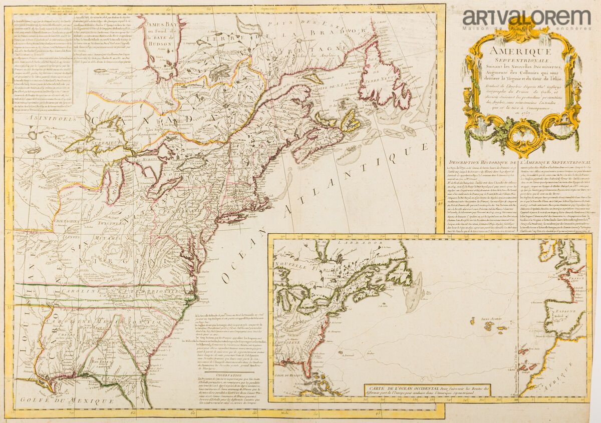
JEFFERYS, Th. Amérique septentrionale, suivant les nouvelles découvertes, augmenté des colonies qui sont derrière la Virginie et cour de l'Ohio. 1757. Borders in antique col. Cartouche and border in later colors. Cut at lower right inside the graduation scale. Printing folds at top center. On heavy paper. 485 x 700 mm. Full title: Amérique septentrionale, suivant les nouvelles découvertes, augmenté des collonies qui sont derrière la Virginie et cour de l'Ohio. Translated from the English after Thos. Gefferys géographe du Prince de Galle, et divisée suivant les pretendues pretentions des Anglois, sans néantmoins entendre, que ce la tire à concequence, en 1757. In cardboard: "Map of the Western Ocean". Rare, separately published map issued during the Seven Years' War (the war against the French and the Indians). Although the map is attributed to Thomas Jefferys by McCorkle, it appears to be a French replica of Jefferys' pro-English map of 1755, "North America From the French of Mr. D'Anville Improved with the Back Settlements of Virginia and Course of Ohio Illustrated with Geographical and Historical Remarks". The map depicts the controversy between the French and English over the lands west of the Alleghany Mountains and in the Ohio Valley. By the time Jefferys' map was published in 1755, the French had defeated the British army near Fort Duquesne. Jefferys had taken the work of French cartographer d'Anville and made modifications to show British claims, identifying French settlements as encroachments on English territory. In response, this map indicates English claims to the area illustrated in Jefferys' map, and states that these claims are disputed by the French. Cardboard: "Carte de l'Océan occidental. Pour faire voir les Routes des différents port de l'Europe pour conduire dans l'Amerique Septenrional". McCorkle, 757.3; Sellers & Van Ee, 73.
34
JEFFERYS, Th. Amérique septentrionale, suivant les nouvelles découvertes, augmenté des colonies qui sont derrière la Virginie et cour de l'Ohio. 1757. Borders in antique col. Cartouche and border in later colors. Cut at lower right inside the graduation scale. Printing folds at top center. On heavy paper. 485 x 700 mm. Full title: Amérique septentrionale, suivant les nouvelles découvertes, augmenté des collonies qui sont derrière la Virginie et cour de l'Ohio. Translated from the English after Thos. Gefferys géographe du Prince de Galle, et divisée suivant les pretendues pretentions des Anglois, sans néantmoins entendre, que ce la tire à concequence, en 1757. In cardboard: "Map of the Western Ocean". Rare, separately published map issued during the Seven Years' War (the war against the French and the Indians). Although the map is attributed to Thomas Jefferys by McCorkle, it appears to be a French replica of Jefferys' pro-English map of 1755, "North America From the French of Mr. D'Anville Improved with the Back Settlements of Virginia and Course of Ohio Illustrated with Geographical and Historical Remarks". The map depicts the controversy between the French and English over the lands west of the Alleghany Mountains and in the Ohio Valley. By the time Jefferys' map was published in 1755, the French had defeated the British army near Fort Duquesne. Jefferys had taken the work of French cartographer d'Anville and made modifications to show British claims, identifying French settlements as encroachments on English territory. In response, this map indicates English claims to the area illustrated in Jefferys' map, and states that these claims are disputed by the French. Cardboard: "Carte de l'Océan occidental. Pour faire voir les Routes des différents port de l'Europe pour conduire dans l'Amerique Septenrional". McCorkle, 757.3; Sellers & Van Ee, 73.