Description
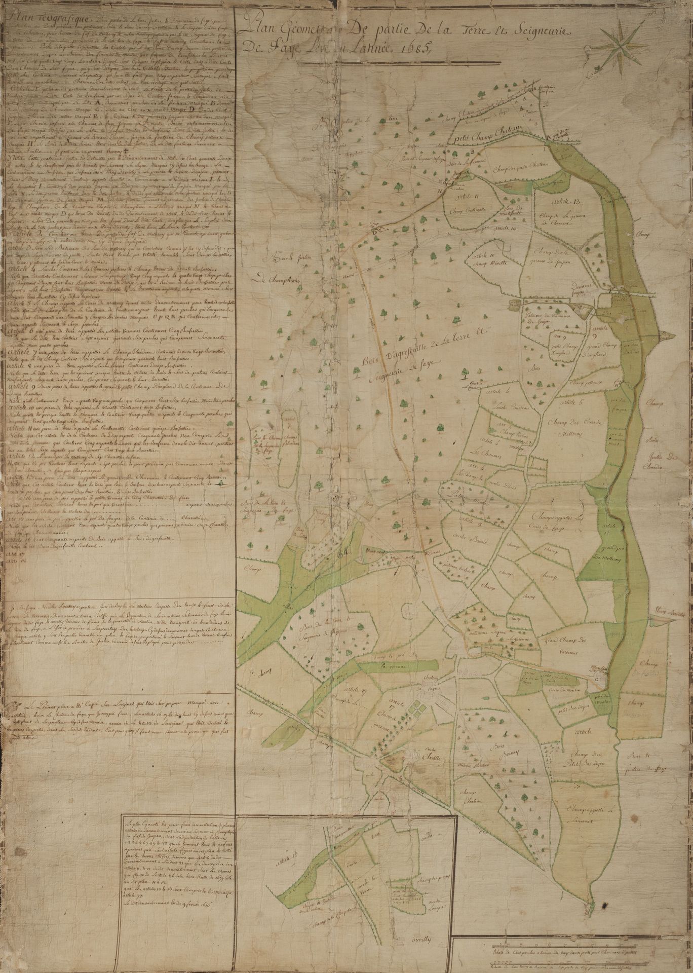
NIVERNAIS. Geometrical plan of part of the land and seigneury of Faye surveyed in the year 1685, pen and watercolor highlights watercolor, on paper pasted on canvas. End of the 17th or beginning of the 18th century. Height : 111 111 - Width : 77 cm (accidents, small lacks, wetnesses) Extremely rare survey plan "copied on the original which was on paper marked with accuracy except the castle of Faye that I could not finish, articles 16, 17 and 18 above as well as the certificate of the surveyor because of the obsolescence of the original which was torn", representing a part of the seigneury of Faye, today covering a part of the commune of Verneuil (Nièvre), detailing and naming the ponds, meadows, forests, river, roads, castle and mill of Faye, etc. The original plan was realized in 1685 by Nicolas Levernay, sworn surveyor of the king in the royal mastery of waters and forests of the province of Nivernais remaining in Nevers at the request of Louis Antoine Sallonnier de Faye, squire of the said Faye and Avrilly, treasurer of France in the generality of Moulins, curator of the waters and forests of Nivernois, in lawsuit against the lord Ducray de Villaine. The castle of Faye, now disappeared, was located along the old road from Châtillon-en-Bazois to Nevers (today's D978) at the point of confluence between the stream of the Fontaine de Grandfond and the the brook of Faye.
72
NIVERNAIS. Geometrical plan of part of the land and seigneury of Faye surveyed in the year 1685, pen and watercolor highlights watercolor, on paper pasted on canvas. End of the 17th or beginning of the 18th century. Height : 111 111 - Width : 77 cm (accidents, small lacks, wetnesses) Extremely rare survey plan "copied on the original which was on paper marked with accuracy except the castle of Faye that I could not finish, articles 16, 17 and 18 above as well as the certificate of the surveyor because of the obsolescence of the original which was torn", representing a part of the seigneury of Faye, today covering a part of the commune of Verneuil (Nièvre), detailing and naming the ponds, meadows, forests, river, roads, castle and mill of Faye, etc. The original plan was realized in 1685 by Nicolas Levernay, sworn surveyor of the king in the royal mastery of waters and forests of the province of Nivernais remaining in Nevers at the request of Louis Antoine Sallonnier de Faye, squire of the said Faye and Avrilly, treasurer of France in the generality of Moulins, curator of the waters and forests of Nivernois, in lawsuit against the lord Ducray de Villaine. The castle of Faye, now disappeared, was located along the old road from Châtillon-en-Bazois to Nevers (today's D978) at the point of confluence between the stream of the Fontaine de Grandfond and the the brook of Faye.