Description
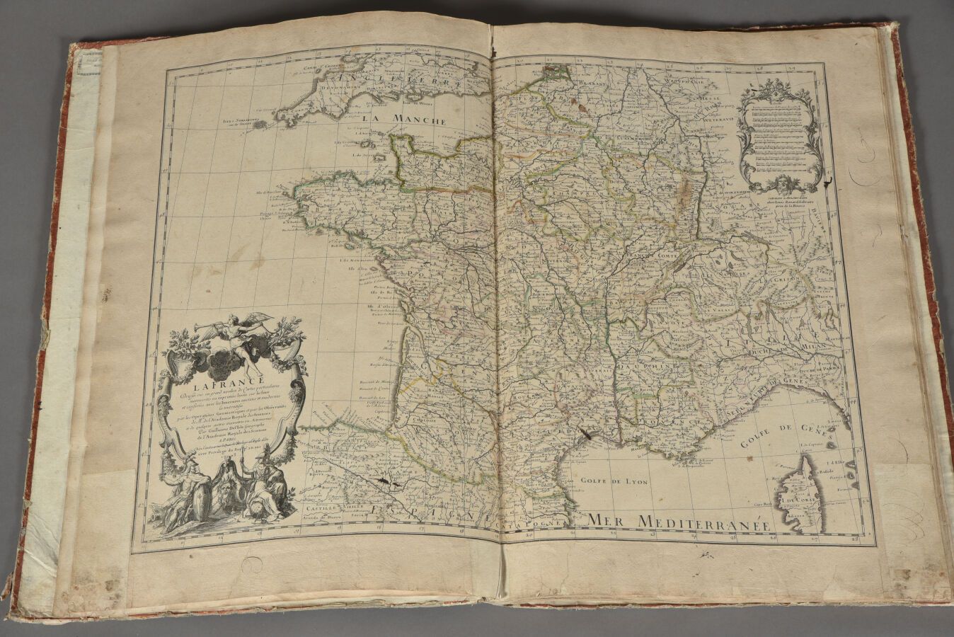
Part of a composite Atlas in which we have the following maps: JEAN-BAPTISTE NOLIN, The Kingdom of Portugal, 1704, double folio, edition coloring. Defects, soiling in the margins. GUILLAUME DELISLE, La France, 1703, double folio. Soiling and defects in the margins. GUILLAUME DELISLE, Map of the Catholic Netherlands, circa 1700, double folio. Soiling etc. in the margins. SANSON and JAILLOT, La Hollande, ca. 1700, double folio. Some defects, map has been reloaded. D'ANVILLE, L'Italie antique, 1764, double folio. Some defects, wetness etc., stains on verso. Cartographe anonyme, Carte générale de la Suisse, circa 1800, double folio. Some defects, stains etc. BRION, Carte de la confédération du Rhin, des états autrichiens et prussiens, 1807, double folio with flap. The map is in poor condition (gaps, accidents, etc.). The Heirs of JEAN-BAPTISTE HOMANN, Circle of Westphalia, double folio, 1756. Some creases and blemishes, the map is remarged on the right. SIEUR LE ROUGE, Carte de la Saxe contenant les routes et les postes, 1743, double folio. Some defects. SIEUR LE ROUGE, Reprise de la carte du Royaume de Bohème, 1742, double folio. Some defects, reinforcement pieces. SANSON, Carte des états de la couronne de Suède, map later taken over by ROBERT, 1741, double folio. Anonymous cartographer, Map of Asia, around the 18th century, double folio. Some defects. JAILLOT, Carte des états de l'Empire des Turcs en Europe, 1700, double folio. Some flaws, the map has been remarged. Dimensions of the Atlas : H. 53,5 cm - W. 36,5 cm.
542
Part of a composite Atlas in which we have the following maps: JEAN-BAPTISTE NOLIN, The Kingdom of Portugal, 1704, double folio, edition coloring. Defects, soiling in the margins. GUILLAUME DELISLE, La France, 1703, double folio. Soiling and defects in the margins. GUILLAUME DELISLE, Map of the Catholic Netherlands, circa 1700, double folio. Soiling etc. in the margins. SANSON and JAILLOT, La Hollande, ca. 1700, double folio. Some defects, map has been reloaded. D'ANVILLE, L'Italie antique, 1764, double folio. Some defects, wetness etc., stains on verso. Cartographe anonyme, Carte générale de la Suisse, circa 1800, double folio. Some defects, stains etc. BRION, Carte de la confédération du Rhin, des états autrichiens et prussiens, 1807, double folio with flap. The map is in poor condition (gaps, accidents, etc.). The Heirs of JEAN-BAPTISTE HOMANN, Circle of Westphalia, double folio, 1756. Some creases and blemishes, the map is remarged on the right. SIEUR LE ROUGE, Carte de la Saxe contenant les routes et les postes, 1743, double folio. Some defects. SIEUR LE ROUGE, Reprise de la carte du Royaume de Bohème, 1742, double folio. Some defects, reinforcement pieces. SANSON, Carte des états de la couronne de Suède, map later taken over by ROBERT, 1741, double folio. Anonymous cartographer, Map of Asia, around the 18th century, double folio. Some defects. JAILLOT, Carte des états de l'Empire des Turcs en Europe, 1700, double folio. Some flaws, the map has been remarged. Dimensions of the Atlas : H. 53,5 cm - W. 36,5 cm.
You may also like