Description
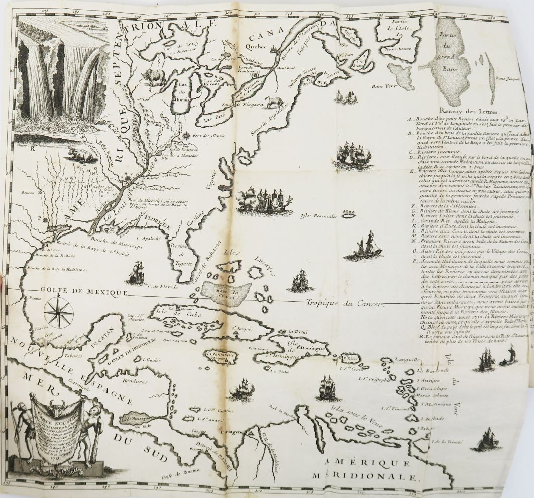
North America - JOUTEL (Henri). Journal historique du dernier voyage que feu M. de la Sale fait dans le Golfe de Mexique, pour trouver l'embouchure, & le cours de la Riviere de Missicipi, nommée à présent la Riviere de Saint Loüis, que traverse la Louisiane. Where we see the tragic history of his death, and several curious things of the new world. By Mr. Joutel, one of the Companions of this Voyage, redigested & put in order by Mr. De Michel. Paris, Robinot, 1713. In-12 of xxxiv-386 pp. Brown calf, spine decorated, title page in red marble (contemporary binding). Headcap removed, some small rubs. Well completed with the beautiful and large folding map representing Louisiana, the course of the Mississippi and the Gulf of Mexico. First edition of this important account of La Salle's ill-fated expedition. Originally from Rouen, the explorer René-Robert Cavelier de La Salle (1643-1687) joined his older brother in New France in 1667 in Montreal from where he launched several expeditions in the Great Lakes region and then along the Mississippi. In April 1682, he took possession of these vast territories along the Mississippi and the Gulf of Mexico in the name of France, giving them the name of Louisiana in honor of King Louis XIV, who initially showed him little recognition. In 1684, La Salle received royal approval for his project to establish a French colony in Louisiana. Unfortunately, after several damages and incidents, his ship left France and deviated from its course to arrive in present-day Texas. La Salle multiplies the attempts to find the Mississippi in vain. A colony is established on the spot but the tensions related to the calamitous voyage worsen: La Salle is murdered by his own men and the few survivors of the colony end up massacred or captured by Indians. Cavelier de La Salle's lieutenant, Henri Joutel, survived by escaping with a few men, including La Salle's brother, to Quebec and then to France. His account of this expedition on his return to Rouen is the best available description of La Salle's last expedition to Louisiana and Texas. "The map that accompanies the work was designed by Joutel, and is the first to give the results of La Salle's last two voyages. It gives a very correct representation of the course of the Mississippi to its mouth" (Church). The map includes portions of the region from the Gulf of Mexico to the headwaters of the Mississippi, and also shows a view of Niagara Falls (Church 855; Sabin 36760.) A good copy of this very scarce work, especially complete with its map which is almost always missing.
852
North America - JOUTEL (Henri). Journal historique du dernier voyage que feu M. de la Sale fait dans le Golfe de Mexique, pour trouver l'embouchure, & le cours de la Riviere de Missicipi, nommée à présent la Riviere de Saint Loüis, que traverse la Louisiane. Where we see the tragic history of his death, and several curious things of the new world. By Mr. Joutel, one of the Companions of this Voyage, redigested & put in order by Mr. De Michel. Paris, Robinot, 1713. In-12 of xxxiv-386 pp. Brown calf, spine decorated, title page in red marble (contemporary binding). Headcap removed, some small rubs. Well completed with the beautiful and large folding map representing Louisiana, the course of the Mississippi and the Gulf of Mexico. First edition of this important account of La Salle's ill-fated expedition. Originally from Rouen, the explorer René-Robert Cavelier de La Salle (1643-1687) joined his older brother in New France in 1667 in Montreal from where he launched several expeditions in the Great Lakes region and then along the Mississippi. In April 1682, he took possession of these vast territories along the Mississippi and the Gulf of Mexico in the name of France, giving them the name of Louisiana in honor of King Louis XIV, who initially showed him little recognition. In 1684, La Salle received royal approval for his project to establish a French colony in Louisiana. Unfortunately, after several damages and incidents, his ship left France and deviated from its course to arrive in present-day Texas. La Salle multiplies the attempts to find the Mississippi in vain. A colony is established on the spot but the tensions related to the calamitous voyage worsen: La Salle is murdered by his own men and the few survivors of the colony end up massacred or captured by Indians. Cavelier de La Salle's lieutenant, Henri Joutel, survived by escaping with a few men, including La Salle's brother, to Quebec and then to France. His account of this expedition on his return to Rouen is the best available description of La Salle's last expedition to Louisiana and Texas. "The map that accompanies the work was designed by Joutel, and is the first to give the results of La Salle's last two voyages. It gives a very correct representation of the course of the Mississippi to its mouth" (Church). The map includes portions of the region from the Gulf of Mexico to the headwaters of the Mississippi, and also shows a view of Niagara Falls (Church 855; Sabin 36760.) A good copy of this very scarce work, especially complete with its map which is almost always missing.