Description
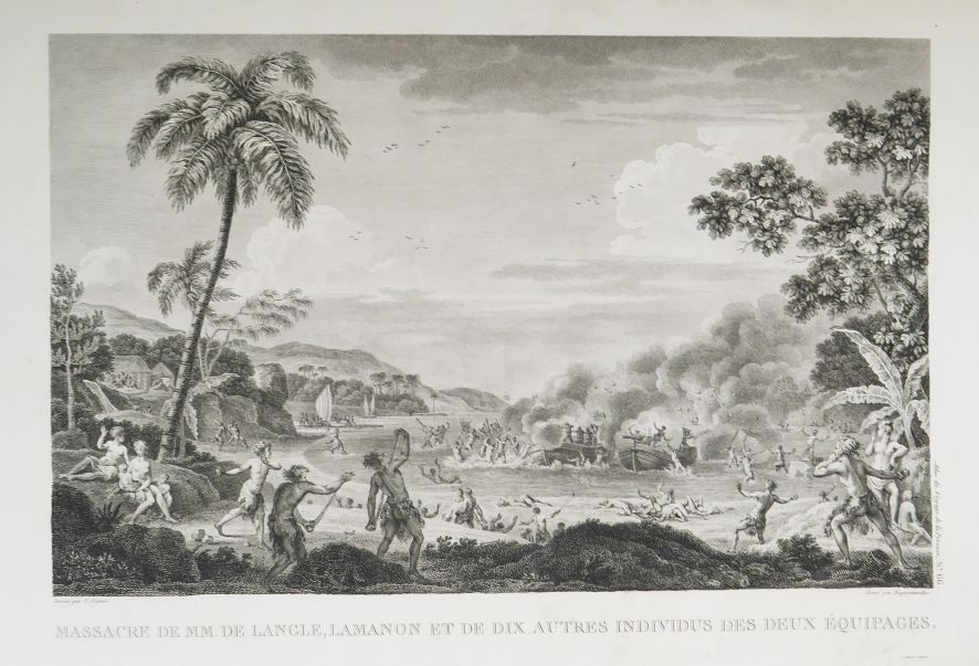
LA PÉROUSE (Jean-François de Galaup de). Voyage de La Pérouse autour du monde, published in accordance with the decree of April 22, 1791, and written by M. L. A. Milet-Mureau. Paris, Imprimerie de la République, An V (1797). 4 vol. in-4 of text in pink marbled paper boards, smooth spines, title label + one atlas in-folio (without binding). Untrimmed copy, the text volumes printed on beautiful strong paper. Volume 1: frontispiece, portrait, title, lxxij-346-(1) pp. small light ring or brown spot in margin of few pages. Volume 2: half-title, title, 398-(1) pp. Small light or russet spots in lower margin in places, small hole in margin of p. 9-10. Volume 3: title, title, 422-(1) pp. paper loss on front covers, small wormholes in upper margin of first 80 pp. (p. 281 at end). Volume 4: title, title, 309 pp. Small hole in false title. Atlas: Portrait of the author pasted on verso of the 2nd endpaper engraved by Alexandre Tardieu after a miniature, title-frontispiece engraved by Ph. Friere after Moreau le jeune followed by 69 plates engraved after drawings by La Martinière, Prévost and Duché de Vancy. Marginal foxing and wormholes on the last plates. ORIGINAL EDITION of one of the most beautiful travel books of the late 18th century. Formidable French scientific expedition in the 18th century in the Pacific and on the American west coast, La Pérouse's voyage was also the first scientific study voyage in California. The illustration includes a portrait of La Pérouse engraved by Alexandre Tardieu (frontispiece of volume 1), and 69 beautiful maps and plates engraved in intaglio by Le Pagelet, Thomas, Godefroy, Choffard, Avril, Legrand... after drawings by Duché de Vancy, Blondela, Prévost, La Martinière... including a large folding world map, 20 double-page maps, 10 full-page maps and 38 plates of views, coastal surveys, natural history, scenes of manners, costumes and native types, all bound in a folio atlas opening on a title-frontispiece engraved by Ph. Trière after Moreau le jeune. France, wanting to complete the numerous topographical surveys that Cook and Clarke had undertaken a few years earlier, in particular those of the Pacific coast of the North American continent, decided on a great expedition around the world. Louis XVI entrusted this mission to La Pérouse. The expedition, composed of two ships, La Boussole (commanded by La Pérouse) and L'Astrolabe (commanded by Delangle), left Brest in August 1785 with many scientists (astronomer, engineer, mineralogist, naturalist, gardener-botanist, draughtsman) on board. The expedition first headed for Brazil and Cape Horn, and then ventured into the Pacific Ocean, exploring the length and breadth of Chile, Easter Island, the Sandwich Islands, Hawaii, Alaska, California, Macao, Manila, the China and Japanese seas, the Tonga Islands and Australia. The boats disappeared at sea while La Pérouse's last letter, written from Botany-Bay (Australia), was dated February 7, 1788, where the expedition had taken refuge after the massacre by Indians of thirteen members of the crew on Maouna Island. In June 1788, the two ships were wrecked on the reefs of Vanikoro in the Santa Cruz Islands. In April 1791, a decree of the National Assembly ordered the publication of the reports, maps and drawings that Lapérouse had sent during his voyage. This official account of the expedition was published by Milet-Mureau based on documents entrusted by La Pérouse to Barthélémy de Lesseps, the expedition's interpreter and historiographer during a stopover in Kamchatka in September 1787, shortly before the tragedy. (Hill 972; Forbes 272; Ferguson 251; Sabin 38960; Boucher de la Richarderie I, 154.)
368
LA PÉROUSE (Jean-François de Galaup de). Voyage de La Pérouse autour du monde, published in accordance with the decree of April 22, 1791, and written by M. L. A. Milet-Mureau. Paris, Imprimerie de la République, An V (1797). 4 vol. in-4 of text in pink marbled paper boards, smooth spines, title label + one atlas in-folio (without binding). Untrimmed copy, the text volumes printed on beautiful strong paper. Volume 1: frontispiece, portrait, title, lxxij-346-(1) pp. small light ring or brown spot in margin of few pages. Volume 2: half-title, title, 398-(1) pp. Small light or russet spots in lower margin in places, small hole in margin of p. 9-10. Volume 3: title, title, 422-(1) pp. paper loss on front covers, small wormholes in upper margin of first 80 pp. (p. 281 at end). Volume 4: title, title, 309 pp. Small hole in false title. Atlas: Portrait of the author pasted on verso of the 2nd endpaper engraved by Alexandre Tardieu after a miniature, title-frontispiece engraved by Ph. Friere after Moreau le jeune followed by 69 plates engraved after drawings by La Martinière, Prévost and Duché de Vancy. Marginal foxing and wormholes on the last plates. ORIGINAL EDITION of one of the most beautiful travel books of the late 18th century. Formidable French scientific expedition in the 18th century in the Pacific and on the American west coast, La Pérouse's voyage was also the first scientific study voyage in California. The illustration includes a portrait of La Pérouse engraved by Alexandre Tardieu (frontispiece of volume 1), and 69 beautiful maps and plates engraved in intaglio by Le Pagelet, Thomas, Godefroy, Choffard, Avril, Legrand... after drawings by Duché de Vancy, Blondela, Prévost, La Martinière... including a large folding world map, 20 double-page maps, 10 full-page maps and 38 plates of views, coastal surveys, natural history, scenes of manners, costumes and native types, all bound in a folio atlas opening on a title-frontispiece engraved by Ph. Trière after Moreau le jeune. France, wanting to complete the numerous topographical surveys that Cook and Clarke had undertaken a few years earlier, in particular those of the Pacific coast of the North American continent, decided on a great expedition around the world. Louis XVI entrusted this mission to La Pérouse. The expedition, composed of two ships, La Boussole (commanded by La Pérouse) and L'Astrolabe (commanded by Delangle), left Brest in August 1785 with many scientists (astronomer, engineer, mineralogist, naturalist, gardener-botanist, draughtsman) on board. The expedition first headed for Brazil and Cape Horn, and then ventured into the Pacific Ocean, exploring the length and breadth of Chile, Easter Island, the Sandwich Islands, Hawaii, Alaska, California, Macao, Manila, the China and Japanese seas, the Tonga Islands and Australia. The boats disappeared at sea while La Pérouse's last letter, written from Botany-Bay (Australia), was dated February 7, 1788, where the expedition had taken refuge after the massacre by Indians of thirteen members of the crew on Maouna Island. In June 1788, the two ships were wrecked on the reefs of Vanikoro in the Santa Cruz Islands. In April 1791, a decree of the National Assembly ordered the publication of the reports, maps and drawings that Lapérouse had sent during his voyage. This official account of the expedition was published by Milet-Mureau based on documents entrusted by La Pérouse to Barthélémy de Lesseps, the expedition's interpreter and historiographer during a stopover in Kamchatka in September 1787, shortly before the tragedy. (Hill 972; Forbes 272; Ferguson 251; Sabin 38960; Boucher de la Richarderie I, 154.)