Description
Automatically translated by DeepL. The original version is the only legally valid version.
To see the original version, click here.
To see the original version, click here.
206
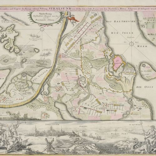
Johann Baptist Homann "Prospect, Ground Plan, and Counterpart of the Royal Swedish Fortress Stralsund". About 1720. Johann Baptist Homann1664 Kambach - 1724 Nuremberg. Copper engraving, coloured at the sides and at the sides on strong handmade paper. Headline in German titled "Prospect, Grundris und Gegent der Königl. Schwed. Vestung Stralsund, wie solche den 15. July A°. 1715 by the Northern High Allies has been besieged. Cum Privilegio Sacrae Caesareae Majestatis by (tit.) Mr. Daniel Heer Royal Polish and Churf. Engineer-Major, and signed by Ioh. Bapt. Homann of the Rom. Keis. Maj. Geographo in Nuremberg". With scale u.l. "Ca. 1:20 000". With a town view of Stralsund and allegorical figures on both sides. Overall a little bit yellowed and creased. Smoothed centrefold. Margins trimmed, partly to the platemark. O. Margins wavy and with several tears (max. 2.5 cm), backed on verso. Tears (max. c. 3 cm) at the margins. Verso with backed vertical centrefold as well as running around the margins. Dimensions: pl. 50 x 59 cm, sheet 52 x 59 cm. Johann Baptist Homann 1664 Kambach - 1724 Nuremberg Engraver a. publisher. In 1687 he got a notary's office in Nuremberg, at the same time he was engaged in engraving. Probably he was a pupil of David Funk. Devoted himself especially to map engraving. 1702 foundation of the publishing house "Homännische Landkarten-Offizin", which was one of the most important map printers in Europe in the 18th century.
dresden, Germany