Description
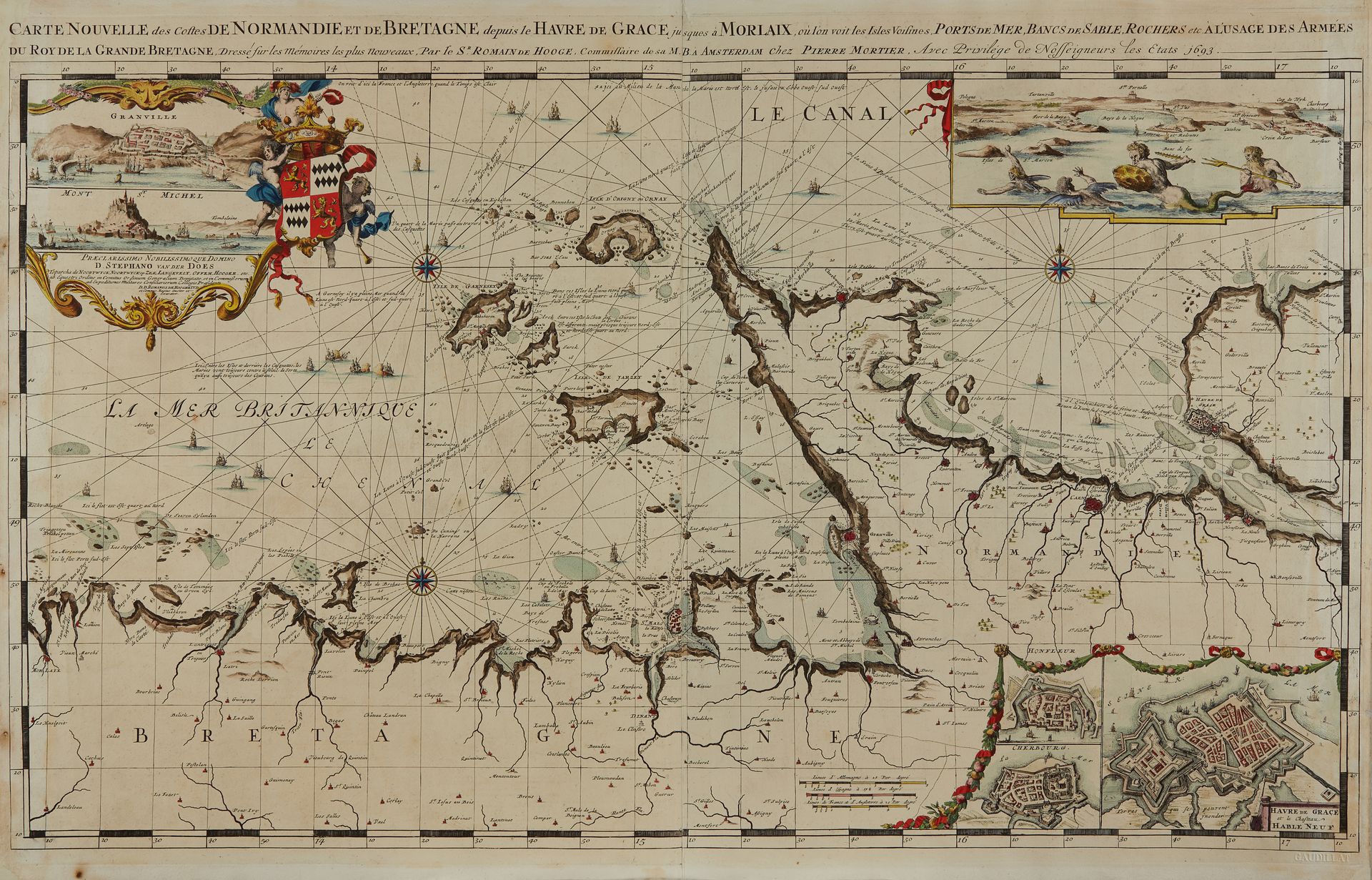
DE HOOGHE, R. Carte Nouvelle des Costes De Normandie Et De Bretagne depuis le Havre De Grace jusques a Morlaix ... Amsterdam, 1693. Col. Washed, restored and coloured copy. 585 x 947 mm. Published in Mortier's atlas "Le Neptune François". Depicts the coast from Fécamp to Morlaix. A cartouche and two maps: 1) to the northwest, with a view of Granville and a view of Mont Saint-Michel. 2) to the northeast, with a view of the north and east coasts of the Cotentin. 3) to the southeast, three plans of cities: Havre de Grace, Honfleur, Cherbourg. Three scales. To the west of the Channel Islands Channel Islands are located the "British Sea" and, just below, the Channel, while while, north of the Cotentin, is the Can. Three wind roses. The Channel Islands are well represented, but let's not forget that the map was intended "for the Armies of the King of Great Britain". The place names around the islands are sometimes in French, sometimes in English, but also in Dutch with a particularity for Chausey: "Ile de Sauzé inhabitée". Many indications in French for navigation. Thirty-two ships at sea, two naval combats, one ship in distress. According to Koeman: ... the most expensive maritime atlas ever published in Amsterdam ... Its maps are larger and more richly decorated than any previously published book. For the engraving, Mortier recruited the most qualified artists. The most beautiful maps in the atlas are those in the second part, by the famous artist, Romeyn de Hooghe. These maps were judged by Koeman to be "the most spectacular type of maritime cartography ever produced". § Copy reproduced in C. Gaudillat, Anciennes Cartes Marines de la Bretagne 1580-1800, Pl. N°23.
79
DE HOOGHE, R. Carte Nouvelle des Costes De Normandie Et De Bretagne depuis le Havre De Grace jusques a Morlaix ... Amsterdam, 1693. Col. Washed, restored and coloured copy. 585 x 947 mm. Published in Mortier's atlas "Le Neptune François". Depicts the coast from Fécamp to Morlaix. A cartouche and two maps: 1) to the northwest, with a view of Granville and a view of Mont Saint-Michel. 2) to the northeast, with a view of the north and east coasts of the Cotentin. 3) to the southeast, three plans of cities: Havre de Grace, Honfleur, Cherbourg. Three scales. To the west of the Channel Islands Channel Islands are located the "British Sea" and, just below, the Channel, while while, north of the Cotentin, is the Can. Three wind roses. The Channel Islands are well represented, but let's not forget that the map was intended "for the Armies of the King of Great Britain". The place names around the islands are sometimes in French, sometimes in English, but also in Dutch with a particularity for Chausey: "Ile de Sauzé inhabitée". Many indications in French for navigation. Thirty-two ships at sea, two naval combats, one ship in distress. According to Koeman: ... the most expensive maritime atlas ever published in Amsterdam ... Its maps are larger and more richly decorated than any previously published book. For the engraving, Mortier recruited the most qualified artists. The most beautiful maps in the atlas are those in the second part, by the famous artist, Romeyn de Hooghe. These maps were judged by Koeman to be "the most spectacular type of maritime cartography ever produced". § Copy reproduced in C. Gaudillat, Anciennes Cartes Marines de la Bretagne 1580-1800, Pl. N°23.