Description
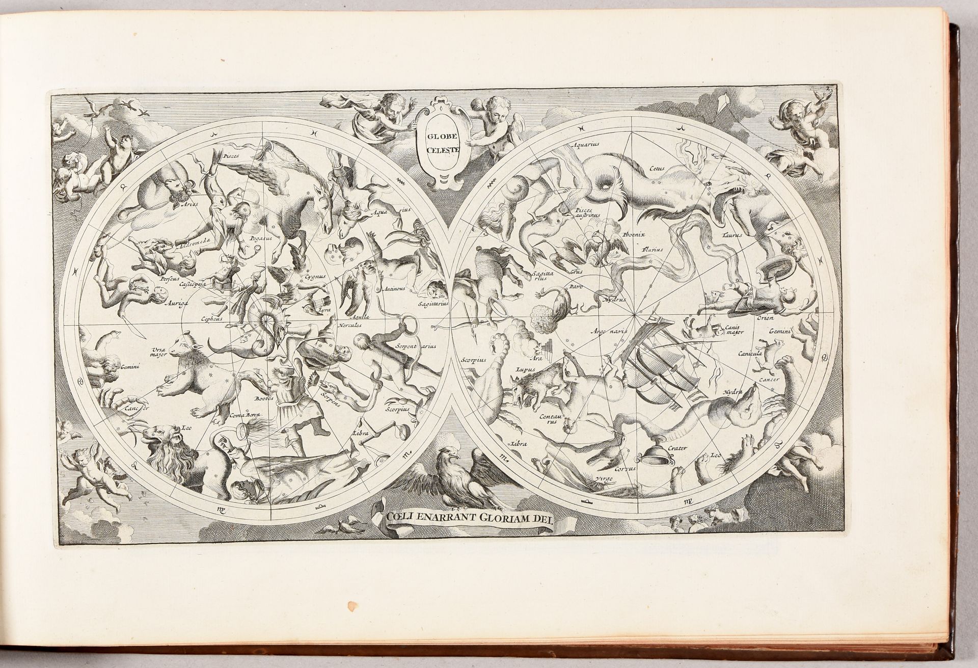
DU SAUZET, Henri Atlas portatif de CCLXXXV cartes, de plusieurs habiles geographes ; où sont representées toutes les parties de la terre. Avec un discours sur la cosmographie, contenant un abregé de la sphere, de la géographie et de l'hydrographie. Amsterdam H. du Sauzet 1734 2 parts in 1 vol., obl. 4to: 16 pp.; 135 pl., 2 pp.; 150 pl. (sm. defects). Contemp. mottled calf, gilt-decorated covers and spine with raised bands (joint partly split, sm. tr. of use). Only 9 copies know worldwide. Very rare and quite unique du Sauzet edition of Cloppenberg's Mercator Atlas with a very typical size of the maps (c. 18,4 x 25,4 cm), between the usual folio maps and these of the Atlas Minor, and with engr. map numbers, indicating that it is the 2nd du Sauzet ed. Nevertheless this early copy has the original Cloppenburch maps of Spain (without 1738), Switzerland, Scotland and Ireland, and some handwritten plate numbers as in the 1st du Sauzet ed. Incl. an engr. title, 2 letterpress titles, A.A. Bruzen de la Martinière's preceding letter, the table of contents listing 285 engr. maps, a celestial map, the world map "Typus Orbis Terrarum" showing the western coast of Australia "Na. Hollandia vulgo T'lant van Eendracht", 9 maps with continents and a plethora of country and regional maps of Europe, Africa, Asia and Sanson's Florida and Canada, Nova Anglia, Nova Virginia, Hispania Nova, etc. Very fine condition, maps in-plano (not folded). Ref. Van der Krogt III [353:42]. - Koeman II, Me 207/208 (= later copy with "127. Hispaniae nova descriptio" dated 1738). - Shirley T.SAUZ-1a.
571
DU SAUZET, Henri Atlas portatif de CCLXXXV cartes, de plusieurs habiles geographes ; où sont representées toutes les parties de la terre. Avec un discours sur la cosmographie, contenant un abregé de la sphere, de la géographie et de l'hydrographie. Amsterdam H. du Sauzet 1734 2 parts in 1 vol., obl. 4to: 16 pp.; 135 pl., 2 pp.; 150 pl. (sm. defects). Contemp. mottled calf, gilt-decorated covers and spine with raised bands (joint partly split, sm. tr. of use). Only 9 copies know worldwide. Very rare and quite unique du Sauzet edition of Cloppenberg's Mercator Atlas with a very typical size of the maps (c. 18,4 x 25,4 cm), between the usual folio maps and these of the Atlas Minor, and with engr. map numbers, indicating that it is the 2nd du Sauzet ed. Nevertheless this early copy has the original Cloppenburch maps of Spain (without 1738), Switzerland, Scotland and Ireland, and some handwritten plate numbers as in the 1st du Sauzet ed. Incl. an engr. title, 2 letterpress titles, A.A. Bruzen de la Martinière's preceding letter, the table of contents listing 285 engr. maps, a celestial map, the world map "Typus Orbis Terrarum" showing the western coast of Australia "Na. Hollandia vulgo T'lant van Eendracht", 9 maps with continents and a plethora of country and regional maps of Europe, Africa, Asia and Sanson's Florida and Canada, Nova Anglia, Nova Virginia, Hispania Nova, etc. Very fine condition, maps in-plano (not folded). Ref. Van der Krogt III [353:42]. - Koeman II, Me 207/208 (= later copy with "127. Hispaniae nova descriptio" dated 1738). - Shirley T.SAUZ-1a.