Description
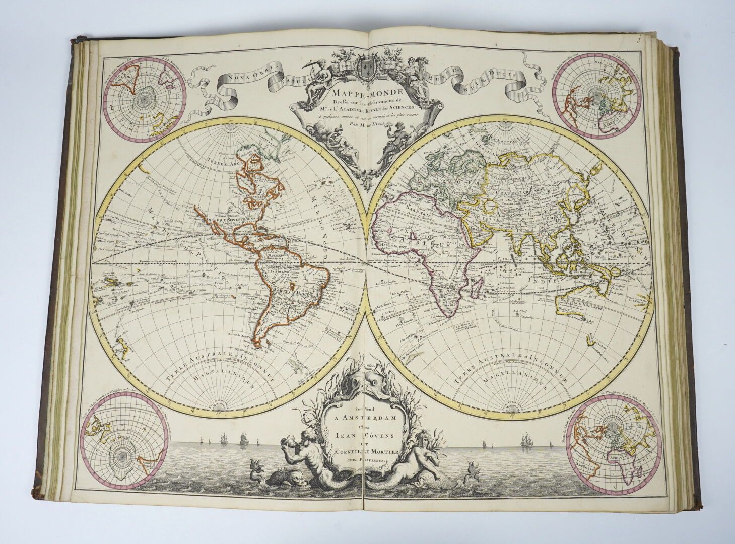
L'ISLE (Guillaume de): Atlas nouveau contenant toutes les parties du monde, ou sont exactement représentées les Empires, Monarchies, Royaumes, Etats, Republiques, etc. par Guillaume de l'ISLE, premier géographe de sa majesté. Amsterdam, Jean COVENS & Corneille MORTIER, 1730. One volume. Avec l'introduction à la Géographie () par le sieur SANSON d'Abbeville, géographe ordinaire du Roy. 33 by 53.5 cm. Engraved frontispiece-(6)-32-(5 manuscript pages)-(5 blank) pages, followed by 61 (of 64) double-page mitered maps. Contemporary full marbled calf, 6-rib spine, decorated boxes, havana title page, triple gilt fillet framing the boards. Binding in good condition, with minor flaws (headbands faded, minor superficial flaws on boards). A few maps cut for a few centimeters at the fold, but not missing. Restored tear on one of the handwritten table leaves. This Atlas is volume 1 of De L'ISLE's Atlas nouveau. Volume 2 is missing. The maps are all in color, measuring 63 by 53.5 cm. They are in a remarkable state of preservation, and of great aesthetic value. The Atlas contains : World map Northern Hemisphere Southern Hemisphere Eastern Hemisphere Western Hemisphere Europe British Isles Northern Courones (Denmark, Sweden, Norway &) second map of the northern crowns Kingdom of Danemarc Muscovy Southern Muscovy Russian Empire Second map of Russia - glacial sea France Surroundings of Paris An added map of Paris and its suburbs from 1772 Map of Paris and its suburbs (in black, fold-out) Guienne and Gascony Generalitat of Tours (fold-out) Anjou and Touraine (fold-out) Bordelois and Périgord Bigorre and Armagnac Diocese of Senlis Diocese of Beauvais Picardy Picardie septentrionale and Artois (map detached, not missing) Champagne and Generality of Chalons Southern Champagne Normandy (fold-out) Brittany Burgundy Northern Burgundy Beauce, Gatinois, Sologne Languedoc Eastern Languedoc Diocese of Narbonne Provence Dauphiné and neighboring countries Diocese of Béziers Diocese of Toul Catholic Netherlands Missing (county of Flanders) Missing (Haynaut, Namur, Cambresis) Artois (map detached, not missing) Missing (Brabant) United Provinces of the Netherlands Germany (map detached but not missing, small tear in margin but not missing) Large theater of war on the borders of France and Germany (with inset plans of strongholds). Course of the Rhine above Strasbourg Rhine from Strasbourg to Worms Rhine from Worms to Bonne Electorate of Hanover Eastern part of the Franconian circle Electorate of Mainz Circle of Bavaria (Latin title cut too short) Posts and roads of the German Empire Southern Swabia Northern Swabia Brandeburg Helvetic Federation Neuchatel and Vallangin Poland Spain Majorca, Minorca, Yvice A total of 61 maps plus one addition. A detailed 5-page handwritten table of the two volumes precedes the maps. Guillaume de l'Isle or Delisle (1675-1726), was a famous cartographer and pupil of CASSINI. In 1718, he produced a map of the Caspian Sea at the request of Peter the Great. A precious and rare atlas, despite the defects of our copy.
55
L'ISLE (Guillaume de): Atlas nouveau contenant toutes les parties du monde, ou sont exactement représentées les Empires, Monarchies, Royaumes, Etats, Republiques, etc. par Guillaume de l'ISLE, premier géographe de sa majesté. Amsterdam, Jean COVENS & Corneille MORTIER, 1730. One volume. Avec l'introduction à la Géographie () par le sieur SANSON d'Abbeville, géographe ordinaire du Roy. 33 by 53.5 cm. Engraved frontispiece-(6)-32-(5 manuscript pages)-(5 blank) pages, followed by 61 (of 64) double-page mitered maps. Contemporary full marbled calf, 6-rib spine, decorated boxes, havana title page, triple gilt fillet framing the boards. Binding in good condition, with minor flaws (headbands faded, minor superficial flaws on boards). A few maps cut for a few centimeters at the fold, but not missing. Restored tear on one of the handwritten table leaves. This Atlas is volume 1 of De L'ISLE's Atlas nouveau. Volume 2 is missing. The maps are all in color, measuring 63 by 53.5 cm. They are in a remarkable state of preservation, and of great aesthetic value. The Atlas contains : World map Northern Hemisphere Southern Hemisphere Eastern Hemisphere Western Hemisphere Europe British Isles Northern Courones (Denmark, Sweden, Norway &) second map of the northern crowns Kingdom of Danemarc Muscovy Southern Muscovy Russian Empire Second map of Russia - glacial sea France Surroundings of Paris An added map of Paris and its suburbs from 1772 Map of Paris and its suburbs (in black, fold-out) Guienne and Gascony Generalitat of Tours (fold-out) Anjou and Touraine (fold-out) Bordelois and Périgord Bigorre and Armagnac Diocese of Senlis Diocese of Beauvais Picardy Picardie septentrionale and Artois (map detached, not missing) Champagne and Generality of Chalons Southern Champagne Normandy (fold-out) Brittany Burgundy Northern Burgundy Beauce, Gatinois, Sologne Languedoc Eastern Languedoc Diocese of Narbonne Provence Dauphiné and neighboring countries Diocese of Béziers Diocese of Toul Catholic Netherlands Missing (county of Flanders) Missing (Haynaut, Namur, Cambresis) Artois (map detached, not missing) Missing (Brabant) United Provinces of the Netherlands Germany (map detached but not missing, small tear in margin but not missing) Large theater of war on the borders of France and Germany (with inset plans of strongholds). Course of the Rhine above Strasbourg Rhine from Strasbourg to Worms Rhine from Worms to Bonne Electorate of Hanover Eastern part of the Franconian circle Electorate of Mainz Circle of Bavaria (Latin title cut too short) Posts and roads of the German Empire Southern Swabia Northern Swabia Brandeburg Helvetic Federation Neuchatel and Vallangin Poland Spain Majorca, Minorca, Yvice A total of 61 maps plus one addition. A detailed 5-page handwritten table of the two volumes precedes the maps. Guillaume de l'Isle or Delisle (1675-1726), was a famous cartographer and pupil of CASSINI. In 1718, he produced a map of the Caspian Sea at the request of Peter the Great. A precious and rare atlas, despite the defects of our copy.